
Worldbuilding Storms and Natural Disasters |Worldbuilding 9|
- Raelyn Teague

- Jul 22, 2022
- 33 min read
Last time we discussed how to worldbuild a basic climate for the various regions of your invented world, but what about day-to-day variations in weather? How do you know when and where it’s likely to rain, when that rainstorm is likely to have lightning, and what parts of your world are likely to see tornadoes? Today we’re going to build off of the discussion from the last post and discuss weather and storms.
Weather can be a fun way to make things more difficult for your adventuring heroes, to put a dampener (see what I did there?) on your military sci-fi general’s battle plans, to force your romantic leads to spend time alone together, or to close your detective in with a potential killer. If you want to throw a storm into the mix, knowing geography, wind patterns, and climate regions for your world can help you figure out what kind of storms are most likely to occur where and when.

First, you know our usual disclaimers apply. This post’s discussion is an overview that will focus on how Earth-like weather occurs. If you depend on complete scientific accuracy, please do further research. And if your world isn’t Earth-like, instead see this post as a way to question and understand how your world works differently.
With those disclaimers out of the way, let’s take a look at some of our world’s most common storms and natural disasters and learn about what conditions make them happen.
HIGH AND LOW PRESSURE SYSTEMS
Before we get into specific types of storms, I wanted to briefly cover high- and low-pressure systems, because they will impact the weather your characters experience day to day.
We already discussed wind belts and prevailing wind patterns, but air also circulates according to air pressure. When two masses of air meet, wind will move in the direction of high pressure to low.
In short, cold air has higher pressure than warm. Hot air rises in part because it has lower pressure, and likewise cold air sinks because of that higher pressure. As this air rises or sinks, it turns. In the northern hemisphere, areas of high pressure turn clockwise as they sink but will turn counter-clockwise in the southern hemisphere. This pattern is reversed for areas of low pressure, however, with air turning counter-clockwise as it rises in the northern hemisphere and clockwise in the southern hemisphere.

Low pressure areas are associated with clouds because of the evaporation of water carried up with rising hot air. Since wind associated with pressure flows from areas of high pressure to low, and since pressure will be lowest in the centre of a low-pressure air mass, winds will flow toward that centre. High pressure systems are instead associated with clearer skies, as the colder, denser air means any moisture will have condensed. But it’s the meeting of high- and low-pressure systems that contributes to a lot of the other weather we experience on Earth.
STORMS WITH PRECIPITATION
Rain. As far as weather goes, this is pretty vital for life as we know it to exist on Earth.
The clouds that pass overhead are filled with evaporated water. Sometimes they carry harmlessly past us without a bother, but other times they bring rain or snow. That precipitation occurs when the water carried in those clouds condenses, returning to water form and carried back to Earth by gravity, but that condensation can occur for different reasons.
Air over water picks up that water, becoming more moist, whereas air over land is drier. Although how much water the air can hold will fluctuate based on things like temperature, there is still only so much water air can hold. As air continues to pick up water from the ocean, eventually that water in the air will have to fall. This means regions of your world near the ocean, particularly regions near a warm ocean current, will see more precipitation than inland regions.
While areas in the middle of a high-pressure air system will see less precipitation, regions in the middle of a low-pressure system will see more of it as that warmer air mass creates clouds that eventually have to drop that extra water they’re carrying.
But rain also happens when a cold air mass and a warm air mass meet to form a frontal surface between them. Because it is lighter and less dense, the warm air mass rises above the cold air mass. Clouds form on the warm side of boundary, but as the evaporated water they carry meets the cold air mass, that water condenses and becomes precipitation on the cold side of the frontal surface. It will fall as rain or, if the cold air mass is cold enough, as sleet, hail, or snow.
There are different ways a warm and cold air mass can meet, so what kind of clouds you see and whether the rain falls in a small location or a wide, light sprinkling depends on which direction these air masses are flowing and how they come together.


When a cold air mass rolls in, the temperature of that region drops as the cold air mass forces the warm air mass above it. Fluffy, cumulus clouds form on the warm side of the boundary and create a more concentrated downpour on the cold side.


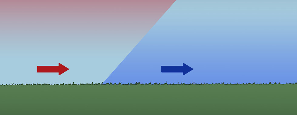


However, when a warm air mass rolls in to meet a cold air mass, air temperature goes up. It will create finer, more feathery stratus clouds on the warm side of the boundary and lighter rain across a wider area on the cold side of the boundary.
These are not the only ways cold and warm air masses can meet, but this should be enough to get you started!
Rain is normally a harmless and even welcome occurrence, especially in places that see little rain or that depend upon it for their crop yields, but while any kind of rain or snowstorm can cause visibility issues or bring winds that might cause trouble for travelers, there are a whole host of other dangers that can arise when that precipitation is too much, comes too fast, or brings friends with it.

THUNDERSTORMS
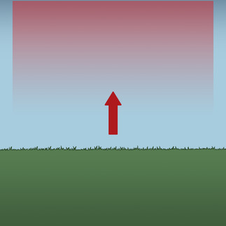
Thunderstorms are a result of instability in the atmosphere and actually work to stabilize it again. They occur when there is a rapid upswell of warm, moist air from the Earth's surface, which creates clouds and a low-pressure zone both beneath and within the forming thunderstorm.
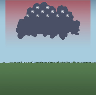
Clouds become heavy and dark as they take on moisture, but that warm upswell of air can only rise so high before it spreads out and cools, turning some of the moisture inside it into ice crystals. As those ice crystals bump against each other, they cause the buildup of a negative charge in the cloud, and lightning occurs to neutralize that uneven, negative charge and the positive charge located in other parts of the cloud, in other clouds, or in the ground.
Though it’s possible to have dry thunderstorms, most commonly in arid areas like deserts where any rainfall might dry up before reaching the ground, typically the cooling of the thunderstorm clouds as they spread means they can no longer maintain all their moisture. The ice in the clouds returns to the earth, bringing with it downdrafts of cold air that lower temperatures and often create strong downward winds. The ice usually melts into rain during its journey, but if the updrafts that caused the buildup of the storm in the first place were strong enough to keep larger ice formations afloat, the ice might not fully melt and might fall as sleet or hail. This fall of rain, ice, and wind cools the updraft of warm air that caused the storm, and without those warm updrafts to continue feeding the storm, the thunderstorm’s life cycle ends, having balanced temperatures and charges.


Thunderstorms are important for stabilizing our atmosphere, but they can also be incredibly dangerous. Dry thunderstorms can cause wildfires, but the downpours, hail, and winds of wet storms can also cause devastating flooding; surface damage to buildings, vehicles, crops, and livestock; and they can even cause deadly tornadoes.
But don’t get too comfortable if the skies look clear, because it’s also possible for lightning to exit a cloud from the back, travel a great distance away from that cloud through clear air, and then to strike the earth. People witnessing these bolts might be too far away to even see the cloud the lightning originated from, and the lightning will seem to have come out of a clear, blue sky. This is where the phrase “out of the blue” comes from. This kind of lightning, while rare, is very dangerous and has killed people.

As one of the most common kinds of storms, thunderstorms can be found all over Earth, but they’re especially frequent in the tropics where an abundance of warm air and moisture, as well as an unstable atmosphere, are common. They might also occur more frequently near certain kinds of topography, such as mountain ranges or near curved coastlines where warm winds might get cornered more easily to create thunderstorms.
Thunderstorms are usually associated with spring and summer, but they can happen in the winter too. Thundersnow storms are much rarer, because cold, winter air tends to be more stable, but if a cold front moves in and forces warmer air above it quickly enough, that friction causes the air to take on a charge. Enter: thundersnow.

However, snow tends to dampen sound, which means that thunder during a thundersnow storm won’t carry as far as thunder during an ordinary electrical storm, and it might only be hearable within a radius of a few kilometres.

FLOODS
When floods happen because of rainfall, it’s because too much rain came too quickly for the ground to absorb it fast enough. A simple enough explanation, but the results can be devastating. The floods make rivers swell and over flood nearby low-lying regions, sometimes blocking off roads, destroying homes and businesses, ruining crops, and killing livestock and people. Flash floods, which occur within six hours after a rainfall, can happen when a heavy rain falls in normally dry areas, but they can occur downstream from any major rainfall.

LANDSLIDES AND AVALANCHES
Landslides can occur after a variety or combination of triggers such as rapid glacial melt, earthquakes, flooding, or heavy rainfall. In the case of rain, when a large rainfall over a steep slope causes the rapid erosion of soil, a landslide may occur, carrying soil, rocks, and vegetation with it. Many landslides happen with little to no property damage or loss of life, but when a landslide occurs near a road or settlement, they can push vehicles off roads or bury towns.
It’s also worth noting that human activity can contribute to and worsen the effect of landslides. Deforestation, whether through wildfires or at human hands, makes the erosion and liquefaction of soil much easier. Mining practices can also weaken the integrity of the land, as was the case for the town of Frank, which was buried under rock when Turtle Mountain’s already unstable structure, the local coal mine, and a wet winter caused part of the mountain to collapse on the town in 1903.

Due to their nature of, well, sliding down a slope, landslides mostly happen in hilly or mountainous regions. So, keep an eye out for those on the map of your world.
Avalanches aren’t the same thing as landslides, but like landslides they occur mostly on steep slopes. When the combination of that slope, a weak layer in the snow cover, and a trigger such as animal movement, a loud bang, warming weather, earthquakes, or a fresh fall of rain or snow causes that weak layer to give way, the snow cover can break off and slide down the slope. Heavy snowfall especially can cause avalanches, as it adds extra weight to already unstable snow cover.
Avalanches can cover roadways or settlements and can be particularly dangerous to skiers and hikers, covering them under as much as several metres of snow in a matter of seconds. Avalanches can be particularly dangerous because, not only can they carry trees or rocks that might cause severe injury, but after the snow slides, it gets packed, which means that even someone buried close to the surface still might not be able to dig themselves out. They might suffocate or develop hypothermia before they are rescued.
Because heavy snowfall is one of the most common triggers of an avalanche, avalanches can occur at any time of year but are most likely to occur during winter and spring when snowfall is most common.

BLIZZARDS
As already mentioned, when a cold air mass and warm air mass meet and the cold side of the frontal boundary is cold enough for precipitation to remain frozen on its journey to earth, that’s when we get snowfall. “Cold” and “warm” is somewhat relative, especially during winter when both air masses are likely to be colder than summertime air, however, the warm air mass does need to be warm enough to absorb a lot of water to cause a blizzard. A true blizzard also comes with strong winds, created by the instability between a high-pressure cold air mass and a low-pressure warm mass. Blizzards cause major visibility issues, can cover roads in a thick layer of snow or turn them to a sheet of ice, and can exhaust and reeze people caught outside.
There are also ground blizzards which aren’t caused by precipitation but are instead caused by high winds picking up snow and ice already on the ground. This kind of blizzard happens when you have strong, sustained winds and a broad, flat landscape with limited interruptions—buildings, hills, or vegetation that would otherwise prevent winds from carrying snow very far. This makes ground blizzards more common in grassland regions. Like other blizzards, ground blizzards also cause visibility issues and can make travel very dangerous.

STORMS WITH WIND
Wind isn’t just that thing that annoyingly blows your hair into your face, it’s also a useful way for animals, people, and even plants to travel. Wind can also play a role in shaping the environment around us through redistributing soil or eroding hills and rock.
In the last post we already discussed how air circulates around the planet in belts caused by the spinning of Earth, causing prevailing wind patterns found across the globe, and today we discussed how winds can also shift direction locally through the exchange of heat and pressure. These winds are one important player in regulating Earth’s temperature, but what happens when those winds turn dangerous?
CHINOOK (FӦHN WIND)
I’m going to use the term “chinook” here, because that’s the term I’m familiar with, but these dry, warm, rain shadow winds go by many other names across the world, such as the Santa Ana winds of southern California, the Bergwind in South Africa, the Nor’wester in parts of New Zealand, and more.
This kind of wind can happen when you have a mountain range occurring perpendicular to the path of prevailing winds, such as the Rockies. In the case of the Canadian Rockies, these winds blow moist air heated from the warm Pacific Ocean currents toward the mountains. As that warm, moist air approaches and ascends the mountains, it cools and condenses, emptying itself of moisture on the windward side of the mountain range. As it crosses over to the leeward side of the mountain range and descends, however, this now dry wind heats up again due to turbulence and the increased solar radiation found on the rain shadow side of the mountains. From there the winds continue their journey, carrying warmth past the reach of the mountains.


Chinooks are common in my part of the world. In fact, during certain parts of the winter, chinooks can occur in one of every three days. These warm winds can also drastically alter the temperature of a region and melt away snow cover like the Earth was popped into a microwave. It isn’t unheard of to have a winter snowfall in the late morning only to have chinooks blow in in the afternoon, raise temperatures by twenty degrees Celsius in the span of an hour, and completely melt away every last snowflake.
For this reason, a lot of people tolerate chinooks, even if they don’t necessarily like the wind blasting in their face every time they step outside. Winters in most parts of Canada are long and cold, but where the chinook blows, it provides periods of relief from cold snaps in the negative thirties.
However, chinooks aren’t entirely benevolent. Many people suffer mild to severe migraines whenever chinooks visit. Light sleepers will find getting and staying asleep difficult as these winds roar through the night, rattle windows, or make trees creak scratch against the house. People with asthma might find themselves especially short of breath. Since Chinooks don’t just warm the air but also dry it, they can also be a contributor to wildfires. And that’s before we talk about how strong these winds can get.
Since these winds occur on the leeward side of a mountain range (which, if you recall, means there’s less likely to be an abundance of trees that might slow these winds down), these winds can vary in power from a nice, warm breeze to hurricane-force gusts of over 150 kilometres per hour. Chinooks can and do push vehicles off the highway. These winds can rip branches as thick as an arm or leg off of trees, throwing them where they might crush a car or take down a powerline.
DERECHO
Many of the storms on this list could easily have been included under the Precipitation section, as wind and rain often go together, making my distinction between rainy storms and windy storms kind of arbitrary, but one of these rainy wind storms is the derecho.
Derechos are associated with chains of severe thunderstorms. They are a long-lasting windstorm with strong, sustained winds and hurricane- or tornado-level gusts that occur over a wide, straight area. They can form when there is a strong jet stream of wind above a thunderstorm. The warm updraft of the thunderstorm hits that fast-moving wind, and when the downstream returns to Earth, it brings some of that jet stream with it from above.

Derechos can cause a lot of damage, bringing with them a lot of rain, lightning, and sometimes flash floods, and because they occur more commonly than tornadoes and hurricanes, they are more likely to be the culprit of wind damage than those other storms. However, derechos can also create tornadoes with the potential to do even worse damage.
In the northern hemisphere, derechos usually occur on the northern side of a high-pressure air mass. In the southern hemisphere, that’s the southern side. Which means these winds usually flow in a west-to-easterly fashion. As it’s that warm draft of air that feeds a thunderstorm and likewise derechos, derechos occur during warm weather.
Location wise, derechos occur mostly in the mid-latitudes. If you go back to our map of Earth’s prevailing wind patterns, mid-latitudes align closely with the pictured wind belts. Derechos occur mainly in the midwestern states, though they can push farther north into Canada, and they can also be found in Brazil, Argentina, and in other countries and continents where they might go by other names.
To find where derechos might occur on your world, look for where your mid-latitudes are coupled with warm temperatures and the edge of a high-pressure air mass.

DUST DEVILS, TORNADOES, AND HURRICANES
I’m lumping these together because they’re all windstorms that involve a column of spinning air, but don’t mistake these for being the same thing, as they’re all distinct.
Dust devils, known by many other names around the world, are the mildest of these wind swirls, and most of the time these guys are harmless. That said, it is possible for dust devils to get as large as 1000 feet tall with peak wind speeds as high as a weak tornado’s, more than enough to cause a little damage.
In order for a dust devil to form, it requires a sunny, calm day and warm weather. This kind of weather can heat up a small area of ground really fast, faster than the areas around it, which causes a small low-pressure zone with rising warm air. The air around it moves in to replace the rising air, causing the air to swirl.

Dust devils are most likely to occur in deserts or dry, flat areas with little tree cover, as these are the places most likely to see the kind of weather and localized heating necessary to create dust devils.
But it’s a different story for a next type of wind swirl: the tornado. Where dust devils require clear, calm days, tornadoes are born out of severe thunderstorms.
Tornadoes—sometimes referred to as twisters, land spouts, or water spouts—require warm, moist, and unstable air near a cold front. They need an updraft of warm air, such as the kind that feeds the supercell thunderstorms most likely to cause tornadoes . As high-pressure air moves in to replace low-pressure air, it causes the air to swirl, and a warm updraft causes that swirl to extend upward toward the clouds, causing funnel clouds. When that funnel touches the ground, a tornado is born.

For the weakest category of tornado, F0, wind speeds range from about 100 to 140 kilometres per hour, which is on par for the strongest wind speeds of a dust devil. Tornadoes, however, can get much, much stronger than that and see some of the most severe wind speeds on Earth. For the strongest, most dangerous tornadoes, wind speeds of over 480 kilometres per hour have been recorded. While tornadoes will often be accompanied by severe lightning and rain that can cause flash flooding, it’s these wind speeds that are the deadliest aspect of a tornado. They cause severe damage to homes, vehicles, power lines. They ravage entire communities. They kill.
Tornadoes tend to be short-lived, lasting as little as a few seconds or as much as slightly more than an hour, but another truly dangerous aspect of tornadoes is how difficult they can be to predict. Where hurricanes can be predicted as much as weeks before their arrival, and residents in the path of a hurricane given days of warning to evacuate, people might only get a fifteen minute-warning between the moment a tornado has actually developed and when it arrives on their doorstep. This makes these storms difficult to avoid or seek shelter from.
Tornadoes can be found six continents, on land or at water as waterspouts, but they are by far the most common in the United States.
Next, we have hurricanes, the longest-lasting and largest, if not fastest, of these wind swirls. Hurricanes are known by a variety of names, including cyclones, tropical storms, and typhoons. Unlike tornadoes and dust devils, hurricanes depend on steady winds and warm ocean water to develop. That means hurricanes will mostly be found in tropical regions and, while they can occur during the spring and fall, the peak hurricane season is during the late summer months when tropical waters are at their warmest. Without that warm water, hurricanes lose power as they enter colder oceans or come on land.

As the air over the warm ocean water heats up, it rises, carrying with it a lot of humidity and, as it cools, turning into the kind of clouds that carry thunderstorms. And, by now, you know how it goes. As that warm air rises, it creates a low-pressure zone, which causes surrounding air to swoop in to replace it. That air also heats up, rises with moisture, and adds to the gathering storm above. The steady winds necessary for the development of a hurricane push those cloud across the water, allowing those clouds to grow as they pick up more and more of the warm, moist air rising from the ocean. Eventually those winds and clouds will start to turn, and as long as they continue to be fed from that warm ocean water, the storm will grow larger and the winds will grow stronger. Tornadoes can be really big storms, but they’ve got nothing on the sheer size of hurricanes, where even just the eye of the hurricane capable of having a radius up to nearly fifty kilometres.
While dust devils and tornadoes won’t last much more than an hour, a hurricane will last as long as it has that warm ocean water to feed it, which can be for weeks. Due to the size and lasting power of hurricanes, settlements in the path of an approaching storm can have dangerous, stormy weather for days before the hurricane finally passes or dies.
The strength of a hurricane’s wind is less than that of a tornado, with wind speeds ranging from 120 to at most a little over 320 kilometres per hour. That’s still plenty strong enough to do damage, but the winds often aren’t the biggest danger of a hurricane. Hurricanes bring with them torrential rains that can cause flooding, and they can also cause storm surge, which is when the force of the approaching storm forces sea waters ahead of it to rise up to 20 feet above sea level. That surge of water can reach dozens of kilometres inland and is responsible for most of the fatalities that occur during a hurricane. On top of that, hurricanes can themselves cause tornadoes, making them even more dangerous.

DUST STORMS
You can get mild dust storms any time you have exposed dirt and debris along with winds strong enough to pick up that dust and keep it airborne for a while. While this can be irritating for people getting dust in their eyes and up their nose, and while blowing dust can cause visibility problems if it’s thick enough to obscure roads or signage, they’re nothing compared to massive dust storms.
Massive dust storms can happen when you have warm, dry ground below but cool rain clouds above. The clouds may try to make it rain, but those raindrops dry up before reaching the ground and are evaporated on the warm, dry air below.
This mass of dense, cold air sitting above less dense, warm air that is trying to rise makes things very unstable, and eventually the cold air descends in a downburst that can be quite strong. This downburst kicks up dust, creating your massive dust storm.

If you’ve got a lot of wind in the area, these dust storms can be carried quite far. Like, across the ocean far. In fact, Central America, the southeast coast of North America, and the northeast coast of South America sometimes get dust blowing in on winds all the way from the Sahara.
Dust storms reduce air quality and visibility, which can make it hard or impossible for travel and transportation on the ground or in the air. As already mentioned, they can be annoying and painful to people or animals caught in all that blowing dust, or they can even be dangerous if shelter can’t be reached.

WILDFIRES AND FIRESTORMS
Okay, so wildfires aren’t a windstorm, but I’m including them arbitrarily here because they can be so much worse when accompanied by wind.
When a region is warm and dry, particularly if it’s been warm or dry for a while, fires can start for any number of reasons: campers don’t put a fire out properly after making smores, someone tosses a cigarette butt out their car window and it lands in the parched grass, a dry thunderstorm ignites a tree, or someone’s gender reveal party gets a little too explosive. However the fire begins, an ample supply of dry grass, brush, or trees turns a few sparks into a raging fire, and the winds spread that fire like, well, wildfire.
Wildfire moves fast. An aggressive fire can skip across streams or other barriers, starting new fires and spreading, and wildfires also have the ability to create firestorms.
A firestorm works similarly to a thunderstorm, with the fire creating a warm updraft of air that is moist due to water vapour from the burning of plant material. When that warm updraft builds towering clouds in the cool air above, you have the same ingredients you need to make a thunderstorm. This storm will rain droplets of water and ash, but unlike a normal thunderstorm, where the rains cool the warm updraft feeding the storm, the fires below a firestorm tend to evaporate any rain before it hits the ground and send it right back up to continue feeding the storm. This means a firestorm can last as much as twelve times longer than a normal thunderstorm. Worse, the lightning from such a dry storm can cause more fires to burn, compounding the problem.

I also wanted to give a brief mention to fire tornadoes, which is a term sometimes applied to two separate phenomena. Usually this term is used to refer to a tornado that forms as the result of a fire. Sometimes wildfires are intense enough that, just as they are able to create thunderstorms, they generate the conditions necessary for producing a tornado.
But the term “fire tornado” is also sometimes used to refer to a fire whirl, which is when the heat rising from a fire interacts with stormy winds to form whirls of burning gases. These are not true tornadoes, as they don’t extend from the clouds to the ground, and they’re more like fire dust devils. In fact, “fire devil” is one of several other names for this phenomenon.
Usually fire whirls are only a few dozen feet tall and short-lived, but intense enough conditions can cause fire whirls that last as much as twenty minutes, are a kilometre tall, and have tornadic wind speeds. No thank you.
Fire whirls can also further the spread of wildfires, as they’re capable of lifting and tossing burning debris where they start new fires.

But while wildfires can be very dangerous and destructive, they are also necessary to the survival of some forests and the animal species who depend on them. Smaller wildfires can act as a form of population control for certain boreal tree species, culling older trees and burning away dead plant material so that seeds can receive enough sunlight to sprout. This not only allows those young trees the space and sun they need to grow, but it also helps clear the forests of plant material that could allow worse, out-of-control wildfires to destroy forests beyond repair.
When wildfires are a threat, there are a few ways people try to deal with them. One of the most important is simply prevention: putting fire bans in place when warm temperatures and dry ground make wildfires a possibility. But once a fire has already started, firefighters will often set smaller, controlled fires in the path of an oncoming wildfire. The idea is to destroy what the wildfire would use for fuel in the hope that when it arrives, the wildfire will have nothing left to feed it and will burn out. But one of the problems with wildfires is how unpredictable they can be. A sudden shift in the wind can mean a wildfire that was headed one way can pull a sharp turn onto a new route of destruction.
Like with dust storms, winds can carry wildfire smoke whole countries away from the fire itself. This smoke can cause visibility issues and lower air quality. Even people far, far away from the fire can develop breathing problems, and people with pre-existing respiratory issues might find the smoke particularly affecting or even deadly.
If wildfires are an issue on your world, another problem your characters might face in the aftermath of a wildfire is the loss of forests, grasslands, crops, and wild and domestic animal life. If the fire is widespread or the result of a drought that was already affecting crop yields, your characters might have to figure out how to survive famine, a loss of resources and income if their business depended on lumber or anything else that might have been destroyed in the fire, or they may even have to deal with looting or a civil war if one class hoards what resources are left after a wildfire.
So, if you want to throw a wildfire, or any storm for that matter, into your story, don’t think just about the damage the storm can do in the moment but about the problems that arise in the aftermath.
UNUSUAL STORMS
So, we’ve gone through our list of some of the most common kinds of storm, weather phenomena, and natural disasters, but Earth has it’s share of really weird storms too. If you’re looking for inspiration for an unusual storm of your own, here are just a few possibilities to get the ball rolling.
PERPETUAL STORMS
While most storms on earth last only a short time, it is possible for air circulation, topography, and climate to all come together in just the right way to create never-ending storms or storms that last months, years, or centuries.
One example is the Great Red Spot of Jupiter, a windstorm that has been raging over the gas giant for a very long time. We don’t know exactly how long this storm has existed, but there are records of people observing what might have been the Great Red Spot from over 350 years ago. So it’s been around a while.
But we have our own example of a perpetual storm here on Earth, too. Lake Maracaibo in Venezuela sees thunderstorms for nearly 300 nights of every year. And these aren’t always mild thunderstorms with a low grumble and rare flash of light either. During their peak season, there can be dozens of lightning strikes every minute, putting on quite the light show.

I mentioned during the section on thunderstorms that topography can create hotspots for thunderstorm activity, and that seems to be the most likely reason for the perpetual lightning over Lake Maracaibo. Surrounded on several sides by mountains, warm, wet winds come in from the ocean, getting trapped over the lake and surrounded by cool mountain air. And that constant meeting of cold and warm air, of course, makes for prime thunderstorm conditions.
So, take a look at the map of your world. Look for warm ocean currents, wind patterns, and topography that might make part of your world a hotspot for stormy weather.
RAINING CATS AND DOGS
Okay, so you’re probably not going to find too many storms that are literally raining cats and dogs, but you might find the rare storm that rains frogs, fish, or other small creatures.
Yup, this is a phenomenon that sometimes happens on Earth, though we don’t know exactly how it happens. It may depend on other storms, such as waterspouts, picking up fish and debris from one area and depositing them in another, but this has never been witnessed. It’s especially unusual because, whatever animal gets rained, they tend to be mostly of the same species rather than a random sampling of critters that might have been picked up by a waterspout.
We still have a lot of unanswered questions when it comes to animal rain, but maybe it’ll be the inspiration you need for a storm in your story.
HYPERCANE
A hypercane is a really, really, really, really big hurricane. We’re talking a hurricane the width of North America. Thankfully, as of now, the hypercane is only a theoretical storm, so don’t stay up too late worrying about when the next hypercane will come to cause mass extinction. Our untimely extinction is far more likely to happen because of something else. Happy thoughts.
A normal hurricane depends on a supply of vapor from warm ocean water interacting with cooler air in the atmosphere above. A hypercane depends on the same but to the extreme, meaning it would need a larger difference in temperature between warm and cool and therefore would require significantly warmer ocean water than we’re used to—about 14 degrees Celsius warmer than record temperatures of today.
One scientist suggested that a large enough meteor plunging into the ocean could rapidly heat the water and provide the right conditions to form one of these calamitous storms. Such a storm could theoretically dwarf a category 5 hurricane and have wind speeds reaching over 800 kilometres per hour.
If you want to have a nasty superstorm in your story, take a look at the conditions that feed the kinds of storms we experience in our world and see if you can’t find a way for your world to bump that up to eleven.

STORMS AND CLIMATE CHANGE
Speaking of how warmer oceans can cause nasty storms, the warming of our oceans and atmosphere through climate change makes dangerous storms more extreme. So, when your neighbour points to a record-breaking blizzard and says it proves climate change is a hoax, they might actually be pointing to proof it isn’t.
It doesn’t take much imagination to picture how climate change can contribute to heat waves and longer, drier droughts, which in turn contribute to worse and worse wildfires. But as we’ve learned in this post, many different kinds of storms, including blizzards, rely on an updraft of warm air to feed them. As average temperatures rise, we don’t only see the melting of glaciers and a rise in sea levels, we see bigger, angrier snowstorms, rainstorms, thunderstorms, hurricanes, tornadoes, and more.
Climate models don’t tell us whether individual storms were caused by climate change—Earth’s climate isn’t static and natural variations in average temperatures, sea levels, and extreme weather have always shifted back and forth across long periods of time—but the data suggests both human and natural contributions to climate change are causing violent storms to occur much more frequently, with more strength, and with more damage and loss of life than even a few decades ago.
If you want to write a story that spans centuries or if you’re creating a centuries-long world history for your story, you might find human-made or naturally occurring climate shifts can add some interesting worldbuilding.
Think about food production. As climate changes, it affects the food we grow. One region that used to be a prime location for growing a staple crop might become too hot and dry or maybe even too wet. Likewise, species important for food production, like bees, may be threatened by shifting climate, further contributing to food shortages or to necessary human innovation in food production.
Think of human migration and power shifts between nations of your world. Changes to where or how food is grown, to what trade routes become favoured as sea levels rise or weather patterns change, to what places are more likely to be affected by the spread of diseases that might accompany changes in climate will affect where people live and potentially which cities, regions, or nations hold the most power in your world. An island nation that used to be a great naval power may find themselves either dying off or invading other lands when rising sea levels begin to swallow up their homeland. When the production of a dye used for paints in an important religious rite moves to a new location, you might find the centre of the entire religion moves with it. A northern nation that used to be frosty and nearly uninhabitable may see an influx of refugees, labourers, and skilled tradespeople as that frosty land warms up enough to be a paradise compared to the fire-raged, sun-scorched lands to the south. Those lands the refugees left behind may become warzones as the people still there fight over what scant resources remain.
Changing climate and weather patterns can provide interesting ways for the history of your made-up world to see the rise and fall of empires, historical wars, and shifts in culture as nations move, collide, and blend.

MAGICAL STORMS
I’m going to refer to storms of a nature we don’t see on Earth as “magical storms,” though if you’re writing science fiction, your invented storm might not be magical in nature, produced instead through biology, technology, or through natural physics not impossible on Earth but plausible elsewhere.
There are too many variables when it comes to magical storms for me to tell you exactly how you should design your magical storm, and I wouldn’t want to get too prescriptive in telling you how to write your story anyway. These worldbuilding blogs are more about giving you ideas and warning you about potential pitfalls than to provide a step-by-step rulebook you’re not allowed to deviate from. But I can still give you some questions to think about that will hopefully aid you in developing a really neat storm for your story.
Are magical storms possible in your world? Are they influenced by climate? Do they influence the climate? Or are they caused by something altogether unrelated?
If you’ve got a magic system in your book, think about whether or not it is either affected by or can itself affect the weather. Maybe your world has aliens or gods who are literally responsible for weather, meaning a blizzard could roll in on a hot summer afternoon just because Frank, the god of rain, is feeling particularly frosty toward his ex-girlfriend that day. Can magic-users in your world manipulate the weather to create storms through their own power? Or maybe instead magic-users in your world can’t use magic at all if it gets too wet (I’m looking at you, Roy Mustang) or cold. In Avatar: The Last Airbender, the Boiling Rock prison prevents firebender prisoners from being able to bend by locking them up in a freezer till they turn blue, and it’s only because Zuko has trained his breath of fire that he’s able to overcome that problem.
If your magic-users can control the weather, think about how common these magic-users are and how that ability to affect the weather would impact the world. If these storm-commanding magic-users are very common on your world, that could have a huge impact on your worldbuilding if you don’t have believable limitations for the magic in place. How common would famines be on your world if adequate rain is never a problem? How simple is sea travel when magic-users can call up the right kind of winds while sending away the dangerous kind? How lucrative is trade when trade routes are never affected by weather and products are never lost or damaged as a result of storms? How quickly would societies advance if they never have to deal with storm-related destruction and efforts to rebuild? What kind of battle strategy do they use if they can command the weather? But if the other side will also have people who can send your storms away, what does battle strategy look like when weather is never an advantage or disadvantage in war? Not to mention, since we learned that storms are often Earth’s way of regulating instabilities in the atmosphere, how would the influence of storm magic impact Earth’s atmosphere? Would the willy-nilly creation of magical storms cause the atmosphere to become unpredictable and cause terrible storms elsewhere? Or would the constant creation of magical storms render your planet’s need to stabilize its atmosphere moot? Maybe there’s no such thing as a natural storm in your world with so many people creating magical ones.
Another thing to consider with your magic system and weather is what source your magic-users draw upon for their magic. If your magic comes from a metaphysical force that covers the world, like the veil in the Dragon Age series of video games, does that metaphysical force react to other forces in the world? Does it have poles? Hot spots? Currents? Does this metaphysical force develop storms of its own that ravage your world until the imbalances in the source are levelled? If so, what kind of impact do those storms have? Do they cause physical damage, killing livestock or pulling roofs off of houses? Do they cause damage only felt by people with the ability to use that magic? Does it make them more powerful or less powerful? Can it hurt them? Or do these storms cause spiritual, biological, or mental damage? Maybe they cause plagues of nightmares or visions wherever these storms go. Maybe they spread a magical illness. There’s a lot of potential for interesting plot or character arcs involving magical storms.

WHAT IS THE MEANING OF STORMS?
The title of this section might seem a little pretentious, but what I mean is for you to think of the significance storms in your world will have for people who live there. What do storms mean on a spiritual or cultural level? What do storms mean on a practical level? And what do storms mean on a personal or individual level?
At the cultural level, think about how well your characters understand storms. Do they understand the physics of how storms work? Do they have instruments, spells, or other methods they’ve developed to accurately predict storms?
Or perhaps your characters believe storms are created by the gods. Is this true for your world or simply a belief that allows people to explain something they don’t understand? Maybe storm prevention for people in your world means following religious rituals, well, religiously. When a really bad storm happens, people start looking for sinners or faithless among them.
Have your cultures developed special festivals or customs to help protect themselves from bad weather or attracting the anger of a storm god? Maybe it means making talismans or amulets to protect against storms is a very lucrative job in places that frequently see deadly weather.
Also think about how storms would impact your world on the practical level. If your people believe the storms come from the gods, it’s possible they don’t do much at all to protect themselves, thinking they can only accept and endure the gods’ wrath until it is abated and that trying to reduce the impact of the gods’ wrath will only incur more of it.
Otherwise, do they build their cities with storms in mind? Do they build barriers to protect against frequent flooding? Do they maintain a belt of tall trees to slow down winds? What do people’s clothes look like? Do they always wear ponchos or carry umbrellas? Do they wear tall shoes to keep them out of the worst of the mud that’s always in the streets? Or, and this can relate to your cultural worldbuilding as well, do rich folks get carried around in palanquins so they don’t have to dirty their shoes in the perpetual mud. Is mud on your shoes a sure sign you’re of a lower class? Think of how your civilizations developed practically to protect some or all of their people from the less desirable aspects of weather and storms, because what kind of weather and storms a region sees most often can easily change the look of the buildings, roads, and clothes people wear.
At the personal level, you might want to consider what kind of storms your characters will have experienced growing up and how much they do or don’t know about how to survive one. If your character was raised in a dry place that seldomly sees anything more than a light sprinkling of rain and almost never has severe flooding, how easily do they adapt when they travel to a place with heavy rainfall and where flooding is a common problem? Do they know what to do in a bad storm? Are they able to keep their cool? What goes through their head during the storm?
Let me give a silly example from my own life. It’s technically not a storm, but I think it will get my point across. Where I live, earthquakes are very rare. So rare I’ve only ever experienced one really mild one. But when it happened, it took a good minute for me to figure out why my fridge was visibly rocking back and forth on its own. The idea of an earthquake happening was so far down my list of expected possibilities that the thought of the chinooks trying to blow my house down or even the local cougar huffing and puffing outside my door seemed infinitely more likely. If it had been a severe earthquake, my fridge might have toppled on me before I even thought to follow earthquake safety guidelines.
But even if you aren’t creating your own fantasy or sci-fi world, you might still find storms play a role in the development or psychology of your characters. Are they a storm chaser who’s fascinated by dangerous weather? Do they have trauma from a really bad storm?

In Ouran High School Host Club, many of the guys in the host club, but especially Tamaki, get really frustrated that their newest member, Haruhi, doesn’t seem to have a normal fear response and faces everything on her own without asking any of them for help. That frustration turns to friction and fights between Tamaki and Haruhi when she puts herself alone in a situation that could have been dangerous. It isn’t until Tamaki catches Haruhi hiding in a wardrobe to outlast her kryptonite, a thunderstorm she’s terrified of, that he realizes Haruhi faces all her fears by herself because she’s not used to having anyone she can rely on for help. A storm brings about a nice moment that allows Tamaki to understand Haruhi better and to show her there are people who want to help her when she needs it.
Think about how storms affect your world not just on a physical level, but also culturally and personally. Do your characters know the right thing to do during a storm? Will they be stuck in a stupor? Will they band together to overcome their fear of a storm and save their lives? Or will they put themselves in harm’s way because their instincts tell them to do the wrong thing? Any way you choose, a storm might shake things up a little and present you with great opportunities to test your characters.
PROJECT: NOVELJUTSU
There are so many variables that determine where a storm can and will form, but for Project: Noveljutsu, I've attempted to determine the most likely places for some of the most common kinds of storms to occur. Going off of the basic climate information I determined in the last post, here are where I'd expect to find some common weather phenomena:

Blowing in from the west across the mountains, strong chinook winds sweep down the rainshadow side of the mountains and out toward the east.

We already determined last time that these areas nearer the warm ocean currents will see much more precipitation. But what about snowfall? While many places in the mainland can see snowfall, the warm ocean currents to the west of the continent will regulate the temperature a bit, meaning snow cover is less likely to be severe or last very long. Instead, these regions further north and with higher altitude near the mountains are the most likely places to see more lasting snow cover. Coupled with strong winds coming down the mountains, this mountain range and the areas immediately east of it are most likely to see any nasty blizzards that come through.

Thunderstorms can and will occur almost anywhere in this world, but the major hotspots for thunderstorms will be on the windward sides of these mountains. The warmer interior of the continent as well as warm air from the ocean will blow in these storms, but the mountain ranges will trap that air, making thunderstorms more likely here.

Since tornadoes are born from severe thunderstorms, this is also the area I figure will see any tornadoes too.

Since we determined last time where the rainshadow side of my mountains are, making these areas drier, sunnier, and less lush, it means that these are going to be where dust devils are more common.

Being in the northern tropical region of this world, hurricanes are most likely to occur in the seas to the east of the lower islands. Since the major wind patterns there flow from east to west, these hurricanes will come in from the east, bringing with them torrential rainfall, potential tornadoes, and a storm surge that could do a lot of damage along the eastern coastline of these islands.

Finally, we need to think of places most at risk of wildfire. Since the rainshadow sides of the mountains are also nearer cold ocean currents that will leave the land drier, these are prime areas for an accidental fire to rage out of control. However, wildfires could be a problem in the centre of the mainland, too. The higher occurrence of thunderstorms coupled with the fact that a lusher environment means the interior is more likely to have an abundance of plant life to burn, a drier than usual season can mean wildfires are a risk.
The day-to-day weather can change rapidly, and even places that aren't hotbeds for tornadoes or are less likely to see a blizzard may still have to deal with those kinds of storms from time to time, but this should help me figure out what kinds of storms are most likely to occur and whether or not the people who live in these areas will be equipped to know how to survive them.
CHALLENGE
For this challenge, I want you to take what you were working on from the last challenge. Last time you should have figured out the direction of the major wind patterns for your world as well as where the warm and cold ocean currents were, assuming your map was anywhere near an ocean. Now I want you to pick at least three kinds of storms and figure out what region of your map will be a hotspot for that kind of storm. To take this challenge one step farther, I want you to think of at least one way any people who live in those areas will have adapted to deal with that kind of storm. Will they have adapted their homes to withstand such a storm? Their clothing? Or maybe they've adapted their behaviour. Are their behavioural adaptations practical, like going indoors during a thunderstorm, or are they superstitious, like clapping their hands three times to protect themselves from lightning?


Comments